
MAC (Awaruite) Nickel Property
Theoretical Lateral Fault Shift, (Awaruite) Nickel Sample Locations, & Results (2012)


2021 - NICKEL ROCK OPTION (Grid Battery Metals)
In 2021, Nickel Rock Resources who held an Option on a portion of the MAC Property, conducted a substantial work program on those claims. A gridded soil sampling survey was designed and tested magnetic high features identified in the 2008 QUEST-WEST Geoscience BC survey.
A total of 1394 soil samples were collected on 65 separate lines with either 50m or 100m line spacing. The sample grid spans from the southern claim boundary 11.9km north with east-west oriented lines ranging from 900m in length to just over 2000m in length. Lines were designed to span across northwest trending magnetic anomalies identified in the Geoscience BC QUEST – West airborne magnetic survey which were believed to be prospective for awaruite-chromite bearing ultramafic rocks.
Nickel values in soils range between 5 ppm and 7627 ppm with an average value of 181.6 ppm. Nickel values show a moderate positive correlation with chromium (0.575) and cobalt (0.488). Chromium values range from 4 ppm to 1065 ppm with an average value of 123.1 ppm and cobalt values range from 0.5 ppm (LOD) and 191 ppm with an average value of 17.6 ppm. Anomalous samples taken to be greater than the 95th percentile value (43 ppm for Co, 397.05 ppm for Cr, and 650.4 ppm for Ni) generally plot along a similar north-northwestern trend within the magnetic highs.
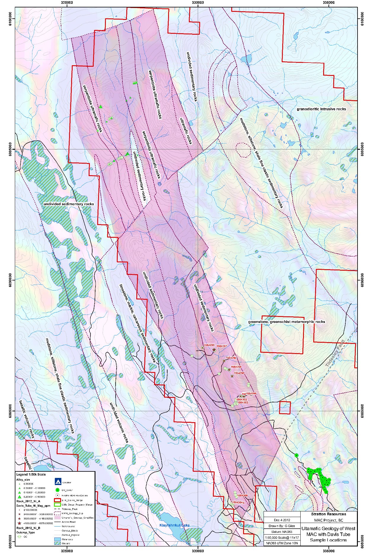
A total of 177 original rock samples were collected and described as variably serpentine-talc-carbonate altered ultramafic rocks with some argillite, basalt, and intermediate intrusive rocks. Altered ultramafic rocks exhibit weak to strong magnetic response. Ultramafic rocks are believed to belong to the Trembleur Ultramafic Unit while sedimentary and intrusive rocks collected outside this unit belong to the Sowchea Succession, Rubyrock Complex, or Sitka Assemblage. Rocks collected along the northwest trending anomaly returned elevated Ni-Cr values, while rocks collected off the anomaly are either argillite or basalt with negligible nickel content.
Rock samples returned values up to 0.37% Ni, 0.32% Cr, and 150 ppm Co with 138 of the 177 samples returning over 0.1% Ni and 123 of the 177 samples returning over 0.1% Cr. High nickel and chromium values are observed spanning across the northwest-trending magnetic feature indicating semi-continuous or continuous Ni-Cr bearing ultramafics and possible nickel alloy mineralization over a strike length of over 16km. Lithology, nickel values in rocks samples, and magnetic response indicate the bodies are tabular, southwest-dipping and up to 600m apparent thickness. Fire assay did not return significant gold, platinum, or palladium values.
A total of 121 rock samples were selected from the original 177 rock samples collected on the Hard Nickel 3 claim block to be tested with Davis Tube magnetic separation. Sample were selected based on highest nickel values reported in original ICP-AES/MS assays. In total 15 of the 121 samples reported no recovered magnetic fraction indicating low quantities of magnetic minerals in these samples. In samples with magnetically recovered fractions, nickel values of the magnetic portions range from 0.16-0.40% Ni with Davis Tube Recovered Nickel values of 4.72 x10⁻⁵% to 0.0758% Ni.
Average DTR nickel in samples with magnetic fractions is 0.0314% Ni. DTR nickel showed no apparent correlation with bulk ICP-AES/MS nickel values, and samples with DTR nickel values appear to be evenly distributed across the prospecting areas.
Three target areas have been selected and are shown in the map below where magnetic highs are likely associated with ultramafic rocks of the Trembleur unit have been identified has high priority targets. In this part of the Property, ultramafic rocks have been previously described to contain visible alloy grains disseminated up to 0.5% visual estimate. Three northwest-southeast trending elongate magnetic high in tenures 1099386, 1099389 and 1099391 require field verification, rock sampling and detailed mapping to investigate spatial nickel concentrations and variations. If strongly magnetic disseminated alloys are present in sampled ultramafic units, rocks should undergo Davis Tube analysis of magnetically separable concentrates to determine DTR Ni% as described in Section 8.
Target Area #1 is the most prospective based on historic sampling and more recent soil sampling across the claims, which displayed anomalous nickel and chromium in soils. Nickel concentrations in soils are up to 7627 ppm Ni, and rocks sampled contained up to 0.0758% DTR Ni. The magnetic anomaly is approximately 8..1 kilometers strike length x 2.3 km width. Further rock sampling and detailed geological mapping is warranted.
Target Area #2 has had minor rock sampling collected over this area. The majority of the previous documented work was focused on the southeast part of the 4 km x 700m feature. Weak to moderate nickel in soil anomalies were noted. Further rock sampling and detailed geological mapping is suggested.
Target Area #3 is relatively unworked by previous operators. Smaller magnetic signatures coincide with northwest trending ultramafic rocks. A few rocks sampled on an adjacent property are were also prospective for awaruite mineralization. Suggested work includes more rock sampling along the western anomalies, and detailed mapping of the structures intersecting through the bedrock.
Many of the target areas are accessible via roads nearby to prospective zones; however, some traverses may require helicopter use to access higher elevations or difficult terrain.


MAC PROPERTY GEOLOGY
The MAC property is underlain by intermediate to basic metavolcanic rocks of the Mississippian-Triassic Cache Creek Group. Numerous intrusions invade the volcanic sequence, ranging from northwest trending serpentinite bodies to granodiorite and quartz monzonite stocks and various felsic dykes (McClintock,1983, Holmgren et al.,1984 and Cope,1989). See Figure 7-3 for MAC Property geological units.
Regional greenschist grade metamorphism of the volcanic rocks has produced a prominent schistosity. Hornfelsing along intrusive contacts has further altered the volcanic rocks, resulting in a brownish-green massive rock with abundant biotite, amphibole, and fine-grained pyrite. These rocks are typically fine-grained and pale to dark green in colour. The volcaniclastic rocks are composed of intercalated massive fine tuff and fine to coarse lapilli tuff. Hydrothermal alteration associated with the intrusion of the quartz monzonite stock includes the development of a quartz stockwork, prominent secondary potassic feldspar flooding, pervasive sericitization of feldspars in the intrusive and the development of quartz lenses in the surrounding hornfelsed volcanics.
Angular lapilli are up to two centimetres across, comprise up to 80% of the fragmental layers and are surrounded by a fine matrix. Light to dark grey massive limestone is exposed in the northeast corner of the southern claim block. A moderate to intense regional foliation, trending 310 to 340 degrees and dipping steeply to the southwest, overprints the volcanic rocks. Where most intense, the resultant rock type is a pale green to grey–green chloritic phyllite with no evidence of original textures.
Numerous intrusions invade the layered rocks. The oldest is a dark green serpentinite forming northwest trending outcrops in the south–central portion of the property. The serpentinite is composed predominantly of radiating laths of tremolite and fibrous talc, and weathers to a distinct orange–buff colour. The serpentinite is assumed to be related to the Trembleur intrusions of Upper Paleozoic age.
A 2.5 by 3 km stock of biotite–hornblende granodiorite is exposed in the southwestern portion of the claims. It is composed of pale yellow–white euhedral 1 to 3 mm feldspar phenocrysts, 1 to 2 mm biotite books and subhedral black hornblende crystals. Quartz phenocrysts to 8 mm are common. A K-Ar date on biotite yielded a Lower Cretaceous age of 141 ± 5 million years (Godwin and Cann, 1985).
In the center of the claim block, a 500 m by 300 m stock of porphyritic quartz monzonite intruding Cache Creek rocks has been outlined. The southern end of the stock is truncated and possibly offset southeastward by a northwest trending, high-angle sinistral fault. Contacts with the surrounding hornfelsed volcanic rocks are not observed in outcrop. Observations from drill holes suggest the contacts are steeply dipping to vertical. The intrusion is medium grained, leucocratic, and porphyritic to equigranular with 15 percent 1-3 mm feldspar, 25 percent 1-2 mm quartz, 35-45 percent 1-4 mm K-feldspar, and up to 5 percent biotite, muscovite, and hornblende (Cope and Spence, 1995). A radiometric age of 136 ± 5 million years has been obtained (Godwin and Cann, 1985). Xenoliths of volcanic rock, a few centimetres to several metres in size, are found near the margins of the stock. Dykes of fine-grained porphyritic quartz monzonite are common. The quartz monzonite body is host to stockwork quartz-molybdenite mineralization as discussed further below. Dykes of biotite-feldspar porphyry cut both the quartz monzonite stock and the host volcanic rocks. Generally, these dykes are pale grey to tan, medium grained with conspicuous 1 to 2 mm biotite books. Locally the dykes are pegmatic with perthitic feldspar phenocrysts to 1 cm. These dykes tend to occur near the margins of the quartz monzonite stock, though not exclusively, and are variably altered and mineralized, and commonly occupy east-northeast trending faults.
The youngest intrusive on the property occurs as dykes of dark green, fine grained amygdaloidal andesite. Calcite-filled amygdules, 1 to 4 mm in diameter, constitute 5% of these rocks.
Soil and glacial cover are extensive and generally shallow but include locally deep mounds that can be over 5 metres thick, particularly in the river valleys. Overall bedrock exposure is poor to moderate but locally abundant in road cuts and in some stream gullies, as well as on steep upper slopes and ridge tops. Glacial striae of 105 degrees have been observed in outcrop on the property (Ditson et al., 2008), which agrees well with the local ice flow directions as shown in the published literature (Plouffe, A., 1997).

ACCESS, LOCAL RESOURCES & INFRASTRUCTURE
MAC is situated in central British Columbia, Canada in the Omineca Mining Division approximately 75 km north-northeast of Burns Lake, B.C., and 80 km northwest of Fort St. James, B.C. (Figure 4-1). The project is centered at latitude 54° 53’ 30” North and longitude 125° 34’ 00” West or 335391 E, 6085753 N (Zone 10, NAD 83) within the area covered by topographic sheet NTS 093K/13, 093K/14 and 093N/04. The property stretches roughly 24 km north to south by about 13 km east to west, covering approximately 190.95 square kilometers.
Access to most of the property is easily gained by well-maintained forestry roads from Fort St. James, via either the Cunningham Road onto Babine Forest Products Road using Cunningham Road to Phantom Road to Fleming Road to Tildesley, or via Canfor Leo Creek 700 to 200 Forest Service Roads crossing from the Fort St. James Forest District into the Nadina Forest District. A network of secondary logging roads provides access to many areas of the property, particularly within the southern portion of the claims. The Project area is easily accessible via well logging roads with several historic exploration access roads nearby the Camp Zone. A network of secondary logging roads provides access to many areas of the property, particularly within the southern block of claims. Though some higher elevation ridges may require helicopter access to conduct work.
Labour and services are readily available from Smithers, Prince George, and Fort St. James. Trucking, expediting, industrial supply, heavy machinery and operators are available.
There are no permanent structures or facilities located on the property. Previous programs established camp in a flattened clear-cut at approximately 26.5 km along Austin FSR. The nearest power supply for a large mining operation is located at Granisle, approximately 40 km west of the property.

ADJACENT PROPERTIES
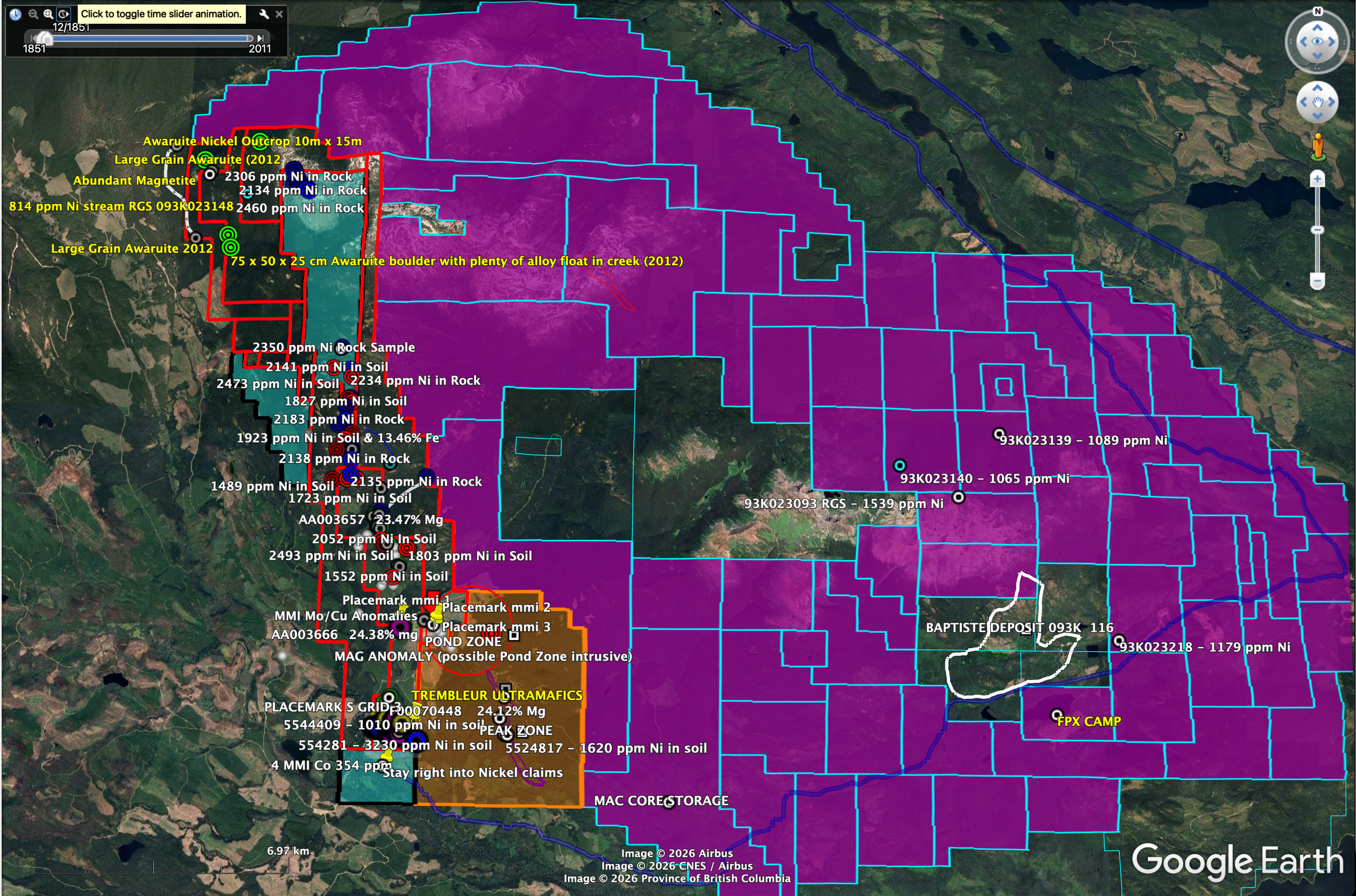
Adjacent to the east of the Property, FPX Nickel is currently undergoing work on the Baptiste awaruite deposit (the “Baptiste Deposit”) of the Decar Property (or the “Property”), central British Columbia (BC), Canada. Awaruite is a nickel-iron alloy (formula Ni2-3Fe) that is strongly magnetic and has a higher density than associated gangue minerals, mostly magnetite and serpentine. Metallurgical testing, shows that awaruite can be concentrated through a simple grinding and magnetic separation process. Since this process captures only the nickel contained within awaruite (and not nickel contained in relict olivine and sulphide minerals), nickel grades are reported as the percent (%) nickel recoverable by Davis Tube magnetic separation (“DTR Ni”).
The Decar Property is underlain by bedrock of the Cache Creek terrane, which includes an obducted Upper Paleozoic and Lower Mesozoic ophiolite of the Trembleur ultramafic unit. Other rocks underlying the Property include metasedimentary and metavolcanic rocks of the Sitlika assemblage and Sowchea succession. Ultramafic rocks of the Trembleur unit are variably serpentinized, with awaruite formed during serpentinization of nickeliferous olivine in the peridotite.
According to BC MINFILE, the claims of the Decar Nickel Project cover seven BC MINFILE occurrences. Since 2008, FPX Nickel Corp. and predecessor First Point Minerals Inc. explored the area of the Decar Nickel Project culminating in the discovery of the Baptiste Nickel Deposit and three other nickel targets on the property: Van, Sid, and B. See FPX Nickel’s website https://fpxnickel.com/ for current information and the approximate locations of the Baptiste deposit and the other targets relative to the company’s claims groups.
On November 14th, 2022 FPX Nickel Corp reported an updated mineral resource estimate for the Baptiste Nickel Project (Flynn and Voordouw, 2022).

MAC NICKEL PROPERTY (Outlined in Red)
A GOOGLE EARTH SHOT OF THE MAC NICKEL SOUTHERN GRID AREA c/w Plotted Results to date