
MAY & JENNIE GOLD MINE

Despite an Indicated Resource of 80,000 tons @ 8.57 gpt Au dating to 1904, the May & Jennie gold deposit was never mined.
In 1983, 58 meters of drift remained open within No.2 adit. Player Petroleum Inc. took 19 chip samples varying from 2.5cm to 0.66m. Assays ranged from 1.83 gpt Au / 8cm (from a cross-cut) to 44.167 gpt Au / 0.42m. Highlights included 31.1 gpt / 0.47m, 28.05 gpt / 0.3m and 14.3 gpt / 0.5m for an average grade of 10.11 gpt Au. In 1986 Player Resources exposed the vein at the surface for 345m, highlighting a 200m section of high-grade. In 2018, BC Mining Properties delineated the vein for approximately 600 meters highlighting more than 300 meters of high-grade structure. The vein/structure remains open in all directions.
Underground, the vein varies from 1.52m to 7.32m wide for an average width of 4.25m and has been traced to 71.6m depth at the lowest point of the workings.
The Red Top is a mineralized structure first discovered and identified as two ledges, 35 feet deep into cemented overburden with the lower being 9 ft. (2.7432m) wide and the upper being 15 ft. (4.572m) with a 24-foot section of schist and dike between, indicating a (single) footwall and hanging-wall type structure. A 40-ft adit driven into the hillside from the footwall section (55m +/-) below the showing had not intersected the hanging-wall section of the mineralized structure indicating a width of more than 88 feet (26.82m). "In this tunnel, some coarse gold was encountered."
The property is located on 2 Mineral Leases good until Feb. 2042 and is fully permitted for a 1000-tonne bulk sample through the end of the 2024 mining season. The May & Jennie has EXCELLENT potential to host gold in the hundreds of thousands of ounces category and has never been meaningfully drilled.
Let’s Make a Few Assumptions…
A common belief and rule of thumb is that in general, a vein will run to a depth of approximately 1/2 of its strike length. We know the May & Jennie has a minimum strike length of at least 600m although it is believed to run 700m or more. The big question is width. Most veins ingratiatingly diminish in width with depth. According to reports, the May & Jennie vein underground (70m +/- depth) has an average width of 4.25m.
Assuming the structure continues to a depth of 300m x 600m long x 4.25m average width x 2.92m3 density = 2,233,800 tonnes converted to tons = 2,462,343 tons x 8.57 gpt equates to a resource of 678,464 ounces gold which would be highly unlikely. The possibility of the vein averaging 2m width based on the same length, depth and density calculation returns 1,116,900 tonnes of material with an assumed average grade of 8.58 gpt Au equal to 307,746 ounces of gold. This calculation has real possibilities and this is only the beginning of the May & Jennie / Red Top Gold story.
As mentioned, the May & Jennie structure is thought to extend more than 700m and may extend the entire width of BC Mining claims (758m). The Red Top Deposit (discussed below) which at this point appears as a separate structure and may also have as much as a 1/2 million ounce or more in gold potential. Please read on…
A 1988 Report written by S.J. Stricker (Report 67443) for Aurora Gold on the May & Jennie Property, Stricker states the following: The undersigned has examined the 1986 drill results closely and proposes a four-fold stratigraphic sub-division on the andesitic interval enveloping the gold mineralization:
Stricker stated: "If the synergetic model proposed is correct, then wide sections of gold enriched rock should be intensely explored for volcanogenic stratabound gold as the sub-economic gold anomalies may grade or down dip into economic gold deposits. Mineralized widths can increase as a result of seafloor paleo-topographic variations if this model is correct, as the gold and sulphides would have been deposited together with the fine-grained pyroclastic debris in a submarine volcanic environment. Furthermore, the economic portions of the Schistose Tuff Unit would be expected to be lensoid or tabular in shape and could occur at more than one level within the stratum, which can be tens of meters thick. Most of the “main structures" remain untested along both strike directions and down-dip”.
Stricker also states “The May and Jennie vein resembles the Silver King deposit in that precious metal zones are concordant within a northwesterly striking, steeply dipping schists derived from Elise Volcanics as well as the property has concordant features and may be genetically closer to the apparently stratabound Silver King deposit that to the true vein deposits of the Nelson and Ymir camps”.
RED TOP GOLD
The 2nd component of the May & Jennie is the Red Top Gold deposit. The upper level of the Red Top is a mineralized structure first discovered and identified as two ledges, 35 feet deep into cemented overburden with the lower being 9 ft (2.7432m) wide and the upper being 15 ft (4.572m) with a 24-foot section of schist and dike between, indicating a (single) footwall and hanging-wall type structure. "A 40-ft adit driven (lower) into the hillside from the footwall section (55m +/-) below the showing had not intersected the hanging-wall section of the mineralized structure indicating a width of more than 88 feet (26.82m). "In this tunnel, some coarse gold was encountered".
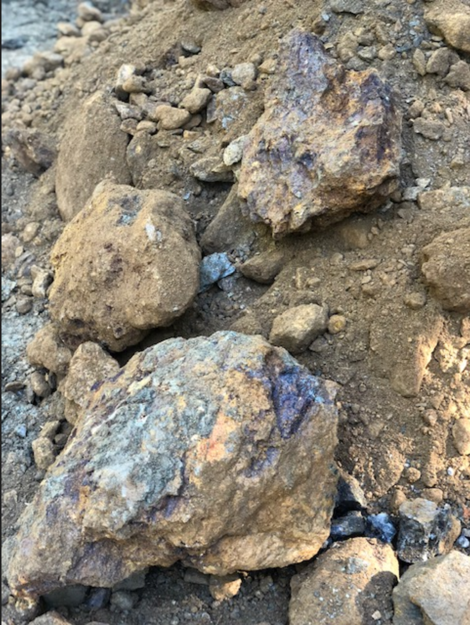
The width and depth of this ledge remain unknown because of limited work and very little exposure because of overgrowth. A historic report references sampling the workings where the average from material taken from the footwall of the adit returned $2.06 gold on $20 per ounce (3.203 gpt) Au. The adit has been located but is sloughed in and was infested with a major wasp or hornet’s nest which after a couple of attempts to investigate, I decided my life was more important. I did snap the best picture I could of the showing which was located exactly when I thought it would be based on historic reports.

In 2020 several grab samples of ore previously unearthed from the upper Red Top showing were gathered of which a single 631 gram was sent out for assay upon an initial XRF analysis. A 34.6-gram portion of the sample rock was retained for reference.

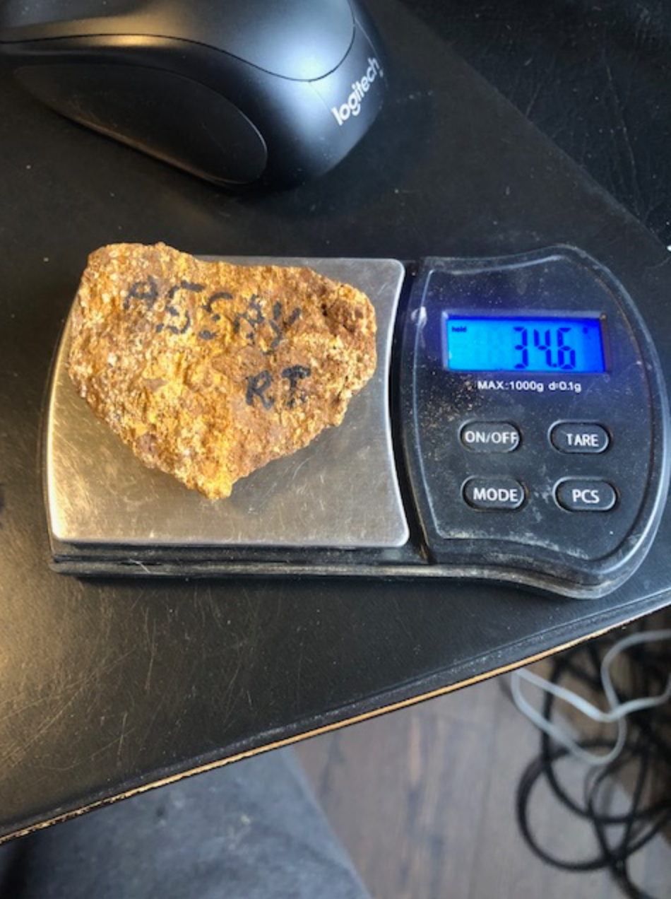
The sample returned an assay of 5.373 gpt Au, 927 ppm W, 301 ppm Co, 29.82% Fe, 17 ppm Bi. A 2nd assay from the same sample returned 1.879 ppm Au indicating the presence of nugget-effected free gold.
A historic VLF geophysical survey (shown below) indicates there may be a significant size to the Red Top structure (approximately 350m x 600m) with an additional trapezoidal area (not outlined) of 300 x 200 x 100 connected to the southern end of the anomaly.
The property is permitted through October 2022 + 2-year extension for drilling and trenching along with the removal of up to 1000 tonnes. Approximately 75 tonnes have been removed to date averaging more than 10 gpt Au.
The May & Jennie and Red Top Mineral Leases Good Until Feb 2042.

1984 VLF EM Survey Above
Historic reports mention the intersection of a quartz structure intersected some distance from the portal while they were driving the #2 Adit. The structure was drifted in both directions for a short distance before continuing the drive to intersect the May & Jennie vein. This same structure was discovered partially exposed along the face of a bank to the left of Adit 1 as you turn the hairpin corner heading up to the Main Drill Road in 2018. The exposure is located exactly on strike approximately 200m South of the location depicted above, which also correlates perfectly with the historic reports Upon trenching, the showing appears to begin exactly where it was discovered or it was mined out below a 6m depth as we were unable to find and track it South of where it was discovered. The exposed showing (in the face of the bank) however, produced quite impressive initial results (additional photos, discussion & Information to follow). Trenching along strike toward the North (where there also happens to be a coincidental VLF conductor branching off of the interpreted May & Jennie vein (see below the pictures). The showing will require much additional exploration and possible drilling to delineate and evaluate its full potential.
A couple of pics below:

Upon exposing the MASSIVE QUARTZ VEIN / BOULDER structure near the #1 Adit area (named #3 VEIN), a 7m+ wide area with sections of schist, massive quartz and quartz boulders containing gold, high-grade chalcopyrite, running copper to around 30% and silver to approximately 400 gpt was disclosed. Initial XRFs also returned anomalous Cobalt. A narrow (chocolate) seam (1”) was sampled (approx. 1 lb. material) and panned, which also returned very nice gold. (see above).
Here link to a sample taken off of one of the boulders seen above - MJ BOULDER SAMPLE
Tons of potential here!

An area outlined by Stricker (above) as having the "best exploration potential particularly around line 10300N where a fold-hinge may be present"


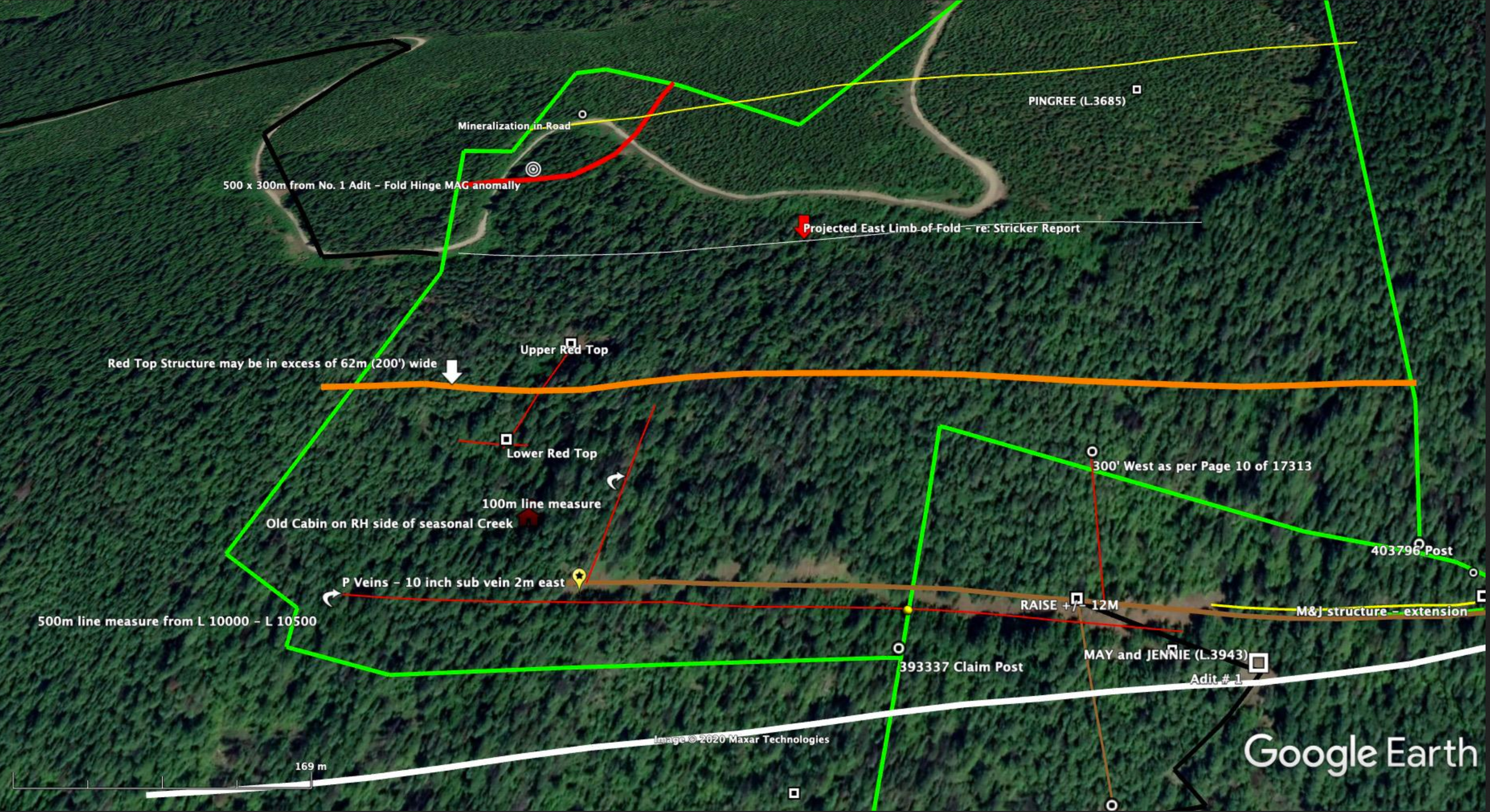

A Conductor (interpreted quartz / boulder structure) can be seen branching off of the May & Jennie Vein to the right

The known Red Top mineralization (left) is plotted on Google Earth as compared to a compilation map (right) depicting the geophysical conductors identified in the 1984 report. Comparing this to Stricker's findings... it all lines up and it all makes sense.

MAY & JENNIE - REPORTS & ASSAYS LINK
May & Jennie Gold Mine History
The May & Jennie Property lies on a 105-acre property comprised of two Mining Leases. The main vein has now been proven to extend more than 600m with a high-grade section extending more than 200m. The showing is located approximately 1/2 km distant from the 49 Creek Watershed and records indicate an existing underground resource of 80,000 tons of ore having been blocked out. This resource would support a small-scale underground mining operation for many years with no additional development to the property. With additional development and drilling expected to commence in the summer of 2021, the May & Jennie / Red Top resource tonnages may easily double or more.
The May & Jennie occurrence is situated at approximately 1371 metres elevation on the east side of Fortynine (Forty-Nine) Creek, approximately 8.5 kilometres southwest of Nelson.
The property is underlain by Lower Jurassic Elise Formation (Rossland Group) augite basalt flows, flow breccias and pyroclastics previously mapped as the Beaver Mountain Formation. Locally, the volcanics have been intruded by dominantly fault-controlled, late-stage, biotite-rich lamprophyre dikes that are probably related to the nearby large granitic stocks and plugs of the Middle to Late Jurassic Nelson Intrusions.
The May & Jennie vein is located on the southwest slope of Forty Nine Creek Valley. Development was carried out on this property between 1900 and 1905, consisting of 610 meters of underground workings. The workings are now caved or flooded and the vein is only partially exposed in adit No. 2.
The occurrence consists of what historically has been interpreted as quartz-pyrite vein mineralization, which is controlled by a major normal fault (the Red Mountain fault) striking 150 to 160 degrees and dipping 80 degrees east. The fault closely follows the trend of the local stratigraphy and schistosity and has numerous associated minor shears. The vein averages more than 1 metre wide at the surface and has now been traced along the surface for approximately 600 metres, although it is thought to have a strike length of more than 700m. The gangue consists of quartz with minor calcite mineralized by fine to medium-grained disseminated pyrite. Wider sections of the fault host massive pyrite with possibly some pyrrhotite and little or no quartz gangue. Locally, a quartz-pyrite–rich envelope extends into the footwall stratigraphy. Assays vary from 1 to approximately 36 grams Au. Free gold occurs in near-surface oxidized zones.
In 1900, the May & Jennie group—the May & Jennie, Red Top, Tip Top Fraction, Cold Bell and Golden Giant claims—were owned by A.H. Kelly. The May & Jennie (Lot 3943) claim was Crown granted to A.H. Kelly in 1900; the Golden Giant (Lot 4655), Gold Bell (Lot 4657) and Tip Top Fraction (Lot 4656) claims were Crown granted to Mr. Kelly in 1901.
The United Gold Fields of British Columbia Limited of London, England, optioned the property in 1900 and began a program of underground development. The No. 1 adit was driven 24 metres to the vein, and 175 metres of drifting was carried out. The No. 2 adit was driven 114 metres to the vein, and 198 metres of drifting was done. A 34-metre raise connected the two levels, and a 30-metre raise was driven to the surface. In 1903, reserves were estimated at approximately 54,431 tonnes (60,000 short tons) ABOVE the No. 2 level.
Extensive surface work was done on the Red Top claim in 1903, though the option was abandoned that same year although there are no records to confirm this. Remnants of a large cabin in the ravine where the structure is located are indications the old timers were chasing something meaningful enough to warrant building the structure below.


Remnants of an old cabin located just below the lower Red Top Adit on left and the Red Top (adit) referred to as the Lower Red Top on the right where course gold was encountered within the 40m long adit.
Construction of a 45.4 tonne/day mill was begun in 1904 by Reliance Gold Mining and Milling Company Limited, which was incorporated in March of that year. Underground workings reached a maximum depth of 71.63 meters, though very little development work was completed that year. Ore reserves were estimated at 72,574.8 tonnes (80,000 tons). Once completed, the cyaniding plant proved to be inadequate, and the mill operated for only a short period in 1906. The company charter was surrendered in 1914 and the mill was dismantled circa 1918. The once-promising mine was never mined.
With the vein open in 3 directions and more exploration to be done, the probability of increasing the size of this deposit is extremely high. Tonnage could effectively quadruple or more upon the completion of some much-needed drilling.
MINISTRY OF MINES ANNUAL REPORTS
1901 Report - 1033
The May and Jennie near Nelson has been developed by 2000 feet of work with good results, but operations have been suspended for the winter.
1900 Report - Page 845
The May and Jennie Group is situated about nine miles west of Nelson,
May and Jennie and consists of the May & Jennie, Red Top, Tip Top, Gold Bell and Golden Giant. These claims are controlled by the United Gold Fields of B. C., with head office in London, England, and of which Mr. J. J. Fleutot is the local Managing Director. During the year work has been done as follows: 1,400 feet of development; 400 feet of flume; 1,200 feet of pipe line; 4,000 feet of trail, and 2,000 feet of wagon road, in addition to which the Company has contributed $2,800 towards the construction of the main road. Two camps have also been built, with accommodation for 50 men. A I0-stamp mill has been ordered which, it is expected to be working by May 1st, 1901, and a saw-mill will also be erected with a capacity of 1,200 feet per day. A tramway is to be built, running distance of 1,000 feet, connecting the mine with the mill, and by the 1st of April, it is expected that 60 men will be at work on these properties.
1903 Report - Pages 143, 144
This property, which is situated on 49er Creek, is connected with Nelson May and Jennie. by means of a wagon road and was systematically developed by the owners throughout the year. Arrangements have been perfected for the organization of a company to take over the property; this plan calls for a mill capable of treating 100 tons per day. Much of the work preliminary to the erection of the mill has already been done. The property is equipped with good boarding and bunk-houses, a flume 2 by 2 has been erected for three-quarters of a mile and is connected with a steel pipe-line 800 feet long to the mill site, giving a pressure of 480 feet, and a retaining wall and foundation has been laid for the mill. The work done in the mine has resulted in the No. 2 level with 60,000 tons of ore carrying good commercial values. The underground work on the property consists of the No. 1 adit, which has been run in for 80 ft. and gives a depth of 125 feet on the vein at the face. There have been 575 feet of drifting on this level, which has shown the ledge to vary in width from 5 to 24 feet, and to carry ore of payable values. The No. 2 adit has been advanced some 375 feet, the: ledge being struck 350 feet in from the portal. Drifting has been carried on north and south from this level along the ledge, the former drift being 400 feet long and the latter 250 feet. There has also been considerable cross-cutting and work disclosing large bodies of ore. Connections have also been made between the two levels by means of a 112-foot upraise, and a second upraise 97 feet in length connects with the surface. Extensive surface work was also been done on the Red Top claim of this group, the washing being cut for a depth of 30 feet. This work uncovered two ledges, one having a width of 9 feet and the other a width of 20 feet, both carrying good gold values. Extensive tests have been made of the May and Jennie ore both as regards milling and cyaniding, and the installation of a mill is all that is required to enable the property to commence producing.
1904 Report - Page 26
Nothing requiring special note has occurred in the Nelson Division this past year unless it be the successful prospecting done on Summit Creek, in the eastern part of the division in the body of this Report the opening up and equipping of the May & Jennie, a large, low-grade gold property in the western part of the division.
Page 135
At the May and Jennie property, in the gold belt to the southwest of Nelson, a 50-ton mill has been erected and will commence grinding on the large reserves of ore blocked out in the mine during the early months of 1905.
Pages 138 & 139
This property is situated on 49 Creek and is owned by the Reliance Gold Mining Company, of Nelson. There was very little development work carried on in the mine during the year, but satisfactory progress was made in the erection of a mill for the treatment of the ore already blocked out. This mill is known as the Akron-Chilian mill and will have a nominal capacity of 50 tons. The buildings have been erected, part of the plant has been installed, and the balance of it is expected to be on the ground in 30 days. The main building is 72 by 36 feet, and the cyanide building 50 by 44 feet. A Riblet tramway has been erected, which has a length of 1,750 feet and connects the mine with the mill, and an ore bin capable of holding 200 tons has been built at either end. Under the process to be introduced, the ore, after it leaves the bin, will be put through a Blake crusher and a set of rolls 14 by 36 inches, crushing to 1/4 inch, and depositing into the mill ore bin. From this it is fed into the Chilian mill, run over the plates, then into the storage tanks, and from these through the cyaniding plant. From experiments made, it is estimated that a saving of 90 percent will be affected by the treatment to be employed. In the mine, the underground workings aggregate half ½ a mile in length, the greatest depth being 235 feet. This has resulted in opening ore reserves aggregating 80,000 tons, the average value of which is expected to be in the neighbourhood of $4 to the ton. As conditions permit of the handling of the output by gravity from the mine through the mill, it is expected that good profit margins will result from mining and milling operations. The probabilities are that the mill will be in operation by the end of April, and preliminary work will be commenced in the mine a few weeks in advance.
1905 Report
The results from the experiments carried on at the May and Jennie mine were also important. Here the adaptability of the Hendryx process has been demonstrated in connection with the cyaniding of ore of the character found so extensively in the May and Jennie workings. The only disappointing feature brought out in connection with these experiments is that the 50-ton plant which the company installed during the year is of insufficient capacity for the profitable working of the property, but with this defect remedied, and the enlarged plant operating on a successful basis, there is every reason to believe that considerable quantities of this character of low grade ore will be profitably treated.
Page 166
The 50-ton mill and cyanide plant which was in the course of erection on this property for several months was completed in July last. Experiments were then made with the ore, which brought out the necessity for considerable adjustment in the cyanide plant, and it was not until December that the desired changes were affected and regular milling commenced. The best commercial results were obtained while milling at the rate of 40 tons per day, the total recovery being 85% of the values. The net result of the experiments carried on may be summed up in the statement that the adaptability of the process applied has been demonstrated; but it has also been shown that to obtain financial results in the working of the May and Jennie property, the capacity of the cyanide plant will require to be very materially enlarged.
The ore reserves in the mine are very extensive, being estimated by the management at 80,000 tons, the average value of which is computed at $4. With the process adopted for the treatment of the ore, and the favourable circumstances attending the mining and handling of ore, the management announces its ability to mine, tram and treat the May & Jennie ore for $1.40 a ton. Work done in the mine consisted of stoping 1,500 tons of ore and breaking down about 3,000 tons in the mine. The milling plant consists of a Chilian mill with a nominal capacity of 50 tons, a Blake crusher, rolls and the “Hendryx electro-cyanide process.”
1906 Report - Page 148
At the May and Jennie property, for which very high hopes were held out through the treatment of a large body of low-grade Gold ore by the Hendryx process of cyaniding, there was practically nothing doing. The insufficient capacity of the cyaniding plant having been demonstrated, milling operations were discontinued and underground exploratory work was undertaken on a limited scale, the ‘progress within the year being insufficient to determine the results.
Sometime before 1918, (the last meaningful mention of the property) everything including the mill was dismantled and removed from the property.
It appears clear the May & Jennie property warranted the full-scale development it was given but in the end, the unproven cyanide leaching system did not perform as expected. I can only assume United Goldfields of British Columbia quickly backed out of their Option Agreement and then only a few years later, the owner of the property (Aaron H. Kelly) passed away suddenly in Victoria BC.
Records indicate that Aarron Hartt Kelly passed away on February 15th, 1911. The probate on his estate settled on January 21, 1928 (almost 17 years later).
Since that time nothing meaningful had been done on the property until Player Resources did work on the property in the mid 1980's. The work they did was consistent with all previous records and grades. Some of which have recently been re-tested and once again, reconfirm the potential of this hidden gem of an undeveloped gold property.

Gold from a 60 lb sample

Gold from a 45 lb sample

Gold from a 140 lb sample

Gold from a 150# sample
Four random May & Jennie Main vein samples of returned gold after crushing and concentrating with a Knelson 7” Prospector Concentrator. The vein was trenched and tested in 23 different locations along the span of the vein. Grades varied as expected with only a couple of spots with no meaningful returns.
The May & Jennie vein has now been exposed at the surface for approximately 600m of which more than 300m +/- returned medium-high and high-grade gold. Preliminary results from the last 100m moving East were somewhat inconsistent at the surface, there is however much reason to believe higher grades will be obtained when we return to this area. Specifically, we identified a sub-parallel structure (approximately 1 ft wide) (part of the same vein, just fading in and out) approximately 2 meters behind the main portion (shown below) which carried high-grade gold as compared to that of the front portion. The "P" vein location was the last exposure of the May & Jennie vein/structure during our 2018 exploration program.

The P Vein (see above) along with an XRF from a small sample taken from the rear portion of the vein (note how appears to have split in two)
STRICKER’S THEORY
The information gathered to date from the Upper, Lower Red Top Vein and Road Vein discoveries in 2018, supports a theory put forth in a 1988 Report written by S.J. Stricker (Report 674436) where he proposes "the May & Jennie structure is "made up of a four-fold stratigraphic of the andesitic interval enveloping the gold mineralization”. After examining drilling logs from the only ever drill program done on the M&J property a year earlier, Stricker also states "if the synergetic model proposed is correct, then wide sections of gold enriched rock should be intensely explored for volcanogenic stratabound gold as the sub-economic gold anomalies may grade or down dip into economic gold deposits. Mineralized widths can increase as a result of seafloor paleo-topographic variations if this model is correct, as the gold and sulphides would have been deposited together with the fine-grained pyroclastic debris in a submarine volcanic environment. Furthermore, the economic portions of the Schistose Tuff Unit would be expected to be lensoid or tabular in shape and could occur at more than one level within the stratum, which can be tens of meters thick. Most of the “main structures" remain untested along both strike directions and down-dip”. Stricker also states “The May and Jennie vein resembles the Silver King deposit in that precious metal zones are concordant within a northwesterly striking, steeply dipping schists derived from Elise Volcanics as well as the property has concordant features and may be genetically closer to the apparently stratabound Silver King deposit that to the true vein deposits of the Nelson and Ymir camps”.